Averting BER Floor with Iterative Source and Channel Decoding for Layered Steered Space-Time Codes
 9 min read
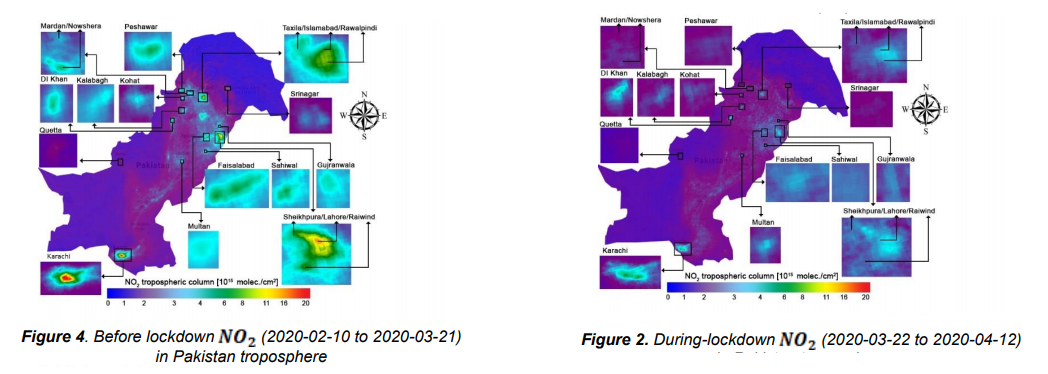
Satellite based remote sensing technology is one of the emerging fields due to their proven significance. This work proposes a sophisticated satellite-based remote sensing system for analyzing tropospheric , that spans from surface up to 10km. The major source of tropospheric is the anthropogenic activities, such as the combustion of fossil fuels including coal, gas and oil and natural processes comprising lightning and soil processes. is one of the major air pollutant and source of acute health effects. In this article, we propose a satellite-based CPS along with the Google Earth Engine (GEE) as our data processing engine. Sentinel-5 Precursor (Sentinel-5p) satellite of European Space Agency (ESA) was utilized to remotely sense temporal atmospheric concentration. In order to investigate the utility of our proposed CPS, we focus on Pakistan as our study region. In order to analyze the disparity in tropospheric during COVID-19 using our proposed satellite-based CPS, we consider pre lockdown period from 10th February 2020 to 21st March 2020, while the observed lockdown period spans from 22nd March 2020 to 12th April 2020. Most of the anthropogenic activities such as public transport, industrial operations were halted due to COVID-19 lockdown in Pakistan. This resulted in a very drastic decrease in the observed atmospheric concentration. This article analyzes the concentrations in Pre-lockdown and during-lockdown in all the major cities of Pakistan. The obtained results show a drastic decrease in concentration, especially 83% reduction in the case of Karachi and the lowest decrease of 51.2% in Gujranwala. Furthermore, our pre-lockdown and during-lockdown analysis show a decrease of 43.3% in the target pollution in the whole country. We also analyzed China and Italy tropospheric using deployed CPS and detected a total decrease of 63.8% in China and 36.9% in Italy tropospheric , respectively.